Sunday, August 24, 2014

Three Guys, Three Days, Three National Parks

Beit Guvrin-Maresha was but the first of four Israeli national parks that we would explore with our friend Naser (well, to date, anyway).  April saw us visiting the other three.  As I'm trying desperately to clear out my blog backlog (backblog?), I'll just knock the rest of them out here in one go.


Beit She'an National Park is located in the northern Jordan Valley.  It was first settled in the fifth century BC on a mound south of the Harod Stream.  For generations, until the Middle Ages, the site was built and rebuilt, causing the layers to grew from a hill into an impressive tel (a prehistoric settlement mound characteristic of the flatter lands of the eastern Mediterranean).  The richest finds from the tel date to the 15th-12th century BCE, when Egypt ruled these lands.  The Egyptians made Beit She'an the center of their rule over Canaan and the Bible mentioned that the Tribes of Israel were unable to capture the city up to the time of King David.  It was here that King Saul and his sons were famously beheaded, their bodies displayed on the city walls following the battle of Gilboa.

From the Hellenistic period up to the Byzantine era, the tel was part of the cosmopolitan Roman city of Scythopolis.  Its striking height imparted special status upon the town, which over the centuries became a central place of worship for pagans and Christians alike.  

Muslims settled the city in the 7th century, but that era was short-lived, as an earthquake razed the city in the year 749.  

The expansive park features many points of interest, mainly from the Roman and Canaanite eras.  

The theatre, containing about 7,000 seats, is the best preserved ancient theatre to be discovered in Israel.  It was built toward the end of the second century CE on the remains of a previous first century theatre.  Today's visitors have a view of the biblical mound and the city streets, but in ancient times walls shielded visitors from such distractions.  Performances were held in the daytime and the seats faced north so spectators had their backs to the sun.  Pantomimes and imitations were the genre of choice, though the occasional athletic competition or acrobatic spectacle found its way to the stage.  


Like other Roman-Byzantine cities, Beit She'an had numerous bathhouses.  Built in the 4th century CE, this 8,500 square meter bathhouse was in use for 200 years, undergoing periodic renovations and alterations.  The compound comprised a number of bathing halls, massage rooms, and public latrines.  Some of the facilities faced an open courtyard with paved mosaic floors.


Palladius Street was one of the more elegant boulevards in Byzantine Beit She'an.  The sidewalks were roofed and paved with mosaics.  The street was named by excavators after a fourth century governors who is mentioned in an inscription found in one of the mosaic pavements.  Along the way you will find the remnants of shops, each with their own beautiful mosaic floor.


The Agora was a Byzantine concourse surrounded by porticoes built in the city center to serve as a hub of commerce and activity.  It became a major center for pottery production during the Umayyad dynasty.

The below piles of rubble may look the same to you or me, but they tell two very different stories.  To the left, we have basalt boulders marking the only remnants of an Israelite fortress dating back to the time of King David and King Solomon.  It was destroyed in a raging fire during the military campaign of Shishak, king of Egypt, five years after the death of King Solomon.  To the right we have the final reminder of an old Canaanite temple.  Five temples were erected on the summit of the tel, one on top of the other, from the 15th to 12th century BCE.  Inside and around the temples were found the remains of altars, ditches, and other structures which served in cultic rituals performed here. 


The day was filled with much more walking and photography, but the discovery of a second bathhouse/public latrine provided my favorite photo ever.

And, since nothing can follow that, we shall move on to another day, and another park.


Nimrod Fortress National Park is, simply, an awe-inspiring sight to behold.  Located on the slopes of Mount Hermon at an altitude of 815 meters above sea level, every corner of the fortress offers a lovely panoramic view of the surrounding valleys.  Nimrod Fortress (aka Qala'at Subeiba) was built in 1220 by Al-Maliq al-'Aziz 'Othman, the governor of Banias, to block passage to the army of Friedrich II, who threatened to march from Akko to Damascus.  

The fortress was expanded and renovated by the Mameluke Sultan, Baybars, during the the 13th century.

The below inscription commemorates and glorifies this reconstruction.  Originally set at the top of the Tower Gate, it was shattered during an earthquake which devastated the fortress.  Most of the fragments were recently sorted and are now displayed along a pathway beside the tower. 


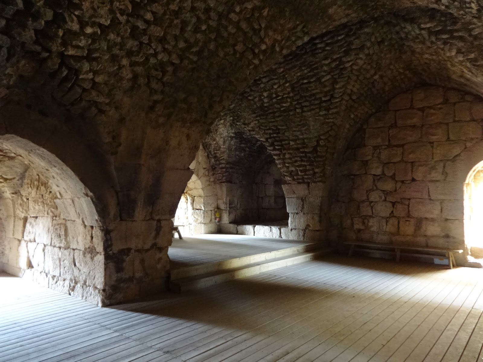
The largest Crusader fortress in all of Israel, Nimrod spans some 420 meters in length and 150 meters in width.  The national park, containing the fortress and the forested mountain on which it rests, covers 49 acres.

The fortress was named after Nimrod, a great hunter-warrior from early Biblical times who was rumored to have built his own castle on the mountaintop.  According to tradition,  Nimrod could sit on the summit and reach out his hand to take water from the Banias Stream below.


We tried to reach the water, and failed.  It was incredibly hot outside, so we found a concession stand and, rehydrated, headed for home.


Tel Hazor National Park is (so far) the only one of this trio of parks to have obtained status as a UNESCO World Heritage Site.  The biblical tels of Hazor, Megiddo and Beer Sheba were inscribed as World Heritage Sites in 2005, and represent 200 biblical tels in Israel, all of which were once flourishing cities.  These cities were established alongside ancient commercial roads and near prosperous agricultural areas.  Archaeological finds attest to urban planning, including gates, walls, temples, palaces, storerooms, stables, and water systems.  These cities existed during the Canaanite and Israelite periods, from the third to first millennia BCE.  


The Meeting Point of the Upper and Lower Cities
Hazor was the largest city in the country during the Caananite period.  It maintained commercial ties with cities in Babylon and Syria, and imported large quantities of tin for the bronze industry.  Approximately 15,000 people inhabited an upper and lower city covering some 200 acres of land.  Hazor was destroyed in a huge fire in the 13th century BCE, after which the lower city was abandoned forever. 


Above are the modest remains of the Palace of the Canaanite Kings of Hazor. The floor of the throne room was originally made of wood. Large quantities of wood were also incorporated into the walls and roof of the building, contributing to the conflagration that destroyed the city.  This particular palace served more of a ceremonial purpose.  The administrative palace is being sought out elsewherein the dig.  

During the Israelite period, a much smaller Hazor (approximately 8.5 acres in size) housed a population of some 1,000 to 1,500 people in the upper city.  Hazor was again destroyed in 732 BCE, this time by Tiglath-pileser III of Assyria's military campaign.  Its residence were exiled along with the inhabitants of the entire Galilee (2 Kings 15:29). 

The mid-1950s excavation of the site was the most important dig undertaken by Israel in its early years of statehood.  To date it is the largest archaeological site in northern Israel…though it certainly didn't feel like it. 


Hazor’s impressive water system, thought to have been built during King Ahab’s reign (9th century BCE), was designed to supply the inhabitants of the city with water in times of siege.  A vertical shaft was dug through the earlier occupation layers, at the bottom of which a sloping tunnel was dug, reaching ground-water at a depth of approximately 40 meters.  These stairs teased the possibility of visiting the cistern, but alas it was closed for renovation.  As the park was empty and the gate was short, I flirted with the notion of hopping the fence and exploring anyway, but TJ shot me a disapproving glance that ruined all the fun. 


The locked gate really does best summarize this site.  There wasn't a whole lot to see.  The city having been destroyed by fire certainly contributes to that, but lots of ancient cities have been devastated by fire and still sport an interesting exhibit or two.  Maybe I've been spoiled by all of the archaeological sites I've had access for recently, such as the first two I discussed today…or maybe there's really just nothing here.  I wouldn't recommend it for the temporary tourist, but anybody living here that collects national parks or UNESCO sites should give it a quick drive-by. 

Wednesday, August 20, 2014

We Met the Trashiest People at Ariel Sharon Park

While perusing Facebook on the evening of Sunday, April 13th, I saw that some of my friends had spent time over the weekend attending a temporary art installation in Tel Aviv that looked pretty cool.  So cool that I simply would have died of anticipation had I been forced to wait an entire work week to go see it myself.  Fortunately, the office was closed on Tuesday, April 15th due to first day of the Passover holiday.  With great glee, I shoved TJ in the car on Tuesday morning and made him drive me to Tel Aviv.
Trash People consists of one thousand life sized humanoid
sculptures made from crushed cans, electronic waste, and other rubbish that, together, form artist HA Schult's critical commentary on human consumption.

"The Trash People are images of ourselves.  We produce trash and we will become trash.  Today's Coca-Cola bottle is the Roman archaeological find of tomorrow...The pyramids of the present are the garbage dumps"

The above quote comes from the official website, which also features numerous photos depicting the exhibit and the stunning locales in which it has been installed since its inception in 1996.  Places such as...

L:  Red Square, Moscow (1999)
R:  Great Wall of China, Beijing (2001)

L:  Pyramids of Giza (2002)
R:  Matterhorn and Lake Stellisee, Zermatt (2003)

L:  Cathedral Square, Cologne (2006)
R:  Piazza del Popolo, Rome (2007)

Israel, however, got a trash dump.  Yes.  That's right.  A trash dump.

Ariel Sharon Park, Tel Aviv (2014)


Ariel Sharon Park is located on top of what was once The Hiriya, a 60 meter high mound of waste.  The landfill is now closed but the conversion process is still underway.  Once completed, the park will be the largest new urban park to be built anywhere in the world over the last century.

When we arrived at the park, which although greatly improved still bears the visual and aromatic scars of its former existence, we felt somewhat shortchanged.  Why were we standing on top of the final resting place of someone's Tuesday night leftovers instead of in front of one of the many iconic attractions that the region has to offer?  How stunning would this exhibit have looked if displayed outside of Jerusalem's Old City?  Sure, you can see Tel Aviv in the background…but it's so far away.

Of course, when one stops to think about it, an exhibit of this nature belongs here.  What better place to acknowledge mankind's addiction to waste than on the site of man's very attempt to correct that flaw?